Friday, August 21, 2015

Ontario Trails News - Trail of the Month


Trailforks Trail of the Month: The Boundary Trail

Aug 31, 2015
by Mark Holloway  

  
TRAILFORKS

The Boundary TrailMiltonOntario, Canada

Trail of the Month


A short 20 minutes drive from the hustle and bustle of downtown Toronto you'll find Milton, Ontario and The Boundary Trail. Sitting directly on top of the Niagara Escarpment are 6 connected forest tracts with 45 trails, making up the Halton Agreement Forests, better known as the "Agreement Forest". Right next-door is an additional 14 neighbouring trails that make up the Hilton Falls Conservation Area. Combined, both networks have over 60 km of trails, ranging from easy access double-track to rock littered singletrack.

 HAFTA.CA

The Boundary Trail will keep all riders on their toes. The intermediate to advanced crowd will have fun negotiating the many skinnies, rock walls and the now famous Gnome Rock that can be found along the way. Novice rider can push their limits or choose to use one of the by-passes which are available at all trail features


The trail took over two years to complete and has seen multiple re-routes since its original layout 10 years ago. The latest changes took place just last year. A section of the trail was located on private land where a new land owner had erected a fence blocking a portion of the original trail. The local trail association, Halton Agreement Forest Trail Association (HAFTA) and a crew of volunteers worked with the landowner, Conservation Halton and IMBA to come up with a plan that would meet the needs of everyone. The re-route was started in the fall of 2014, extensive amounts of rock were moved to add technical trail features. HAFTA volunteers put the final touches on the new re-route this past spring and built the Revolver by-pass, resulting in a trail that's even more challenging than the original.

Gnome Rock
Gnome Rock. HAFTA.CA


A small parking area can be found right at the trailhead to The Boundary Trail. Additional parking is available directly across the road in the Mohawk Race Track parking lot. Between late May and early September bug spray is highly recommended as the mosquito's can be relentless. If you plan to venture into the Hilton Falls Conservation Area portion of the network you're encouraged to purchase a day pass or a yearly membership to help support the work they do and amenities they offer. Amenities include, fire pits for cold fall rides, washrooms and trails like Bent Rim and Hilton's Hwy, which will definitely keep you coming back for more.


If you like what you see then please support our friends at the Halton Agreement Forest Trail Association and earn some Trail Karmawhile you're at it.

Thursday, August 20, 2015

Ontario Trails News - Kayak Commute for Downtown Executive, Kingston


By Ian MacAlpine, Kingston Whig-Standard
Sushee Perumal, the CEO of MaxSold, kayaks from his home in Barriefield Village on Tuesday to downtown Kingston while the Lasalle Causeway is closed for repairs. (Ian MacAlpine/The Whig-Standard)
With some east-end commuters stuck in traffic and perhaps boiling over with stress due to the temporary closure of the Lasalle Causeway on Tuesday morning, Sushee Perumal enjoyed a leisurely kayak ride to work downtown.
Perumal, the chief executive officer of MaxSold, an international online auction business headquartered in Kingston, took only 20 minutes to kayak from his home in Barriefield to his office on Ontario Street.
Perumal who usually cycles or walks to work, thought a kayak trip during the causeway’s closure was the best option to make it downtown.
He also used the exercise as an example of overcoming a challenge in a creative way.
“We’re always encouraging MaxSold employees to be relentless in getting it done regardless (of the challenge),” he said. “This is a good example.”
MaxSold, a five-year-old company, has about 250 employees, with the number expected to go up to 2,000 in the next year at all of its locations. It was founded by local auctioneer Barry Gordon.
If Perumal had walked or used his bicycle on Tuesday, there would have been no way he could have crossed the causeway. While the work is being done Tuesday and Wednesday, the public works department is offering free taxi rides up to Hwy. 401 and back downtown to people trying to get across.
“The mission is to get to the office and there are two or three ways of doing it, and one of the ways was taking a kayak over,” Perumal said.
Perumal’s route saw him head across the Cataraqui River from Barriefield, past Anglin Bay and under the west end of the causeway near Fort Frontenac, where he had to keep low going under the cement portion of the causeway. He then paddled around the breakwater at the Flora MacDonald Confederation Basin to the boat slips just south of the Delta Kingston Waterfront Hotel and steps from his office.
Perumal took some selfie photos along the way.
He said the trip was easy — perhaps a little too easy.
“Just a steady breeze, no huge swells. (That) would have been fun, though.”
“It’s a lot shorter than I thought it was. It probably takes the same time as me walking across (the causeway), and driving takes longer.”
He said in the summer he kayaks three to four times a week. Sometimes he goes to Cedar Island and Belle Island Park.
“There’s lots of places to get to.”
Perumal said he may keep kayaking to work in the future, even when the causeway is open.
“It’s now one of my three options, now that I know it’s a fast kayak and it’s nice to do in the morning,” he said.

Wednesday, August 19, 2015

Ontario Trails News - Cycling in Canada


Cycling in Canada: Exploring the Muskoka region of Ontario, from Bala to Torrance and back again

It might not be quite the same thing as actually taking part in the MEC Muskoka Ride, which our editor participated in today, but this video — posted to YouTube by user “TamFruit” — provides a tantalizing, even teasing sample of what makes cycling in Ontario’s Muskoka region such a beautiful, zen-like experience.
Last weekend, we showed you what it’s like to bike along the sea in Vancouver, in the shadows of Stanley Park conifers with a view of the masts of moored boats. Today, we rocket over to the other side of the country, through the community of Bala, Ont., to Torrance, and back to Bala. Riding along highway 169 and through other parts of the region, TamFruit’s video showcases the equally unique splendor of a ride through the backyard of the most populous part of the country.
And as you can see, the fact that Canada’s largest city is barely hours away doesn’t do much to diminish the pristine, almost rustic splendour of the Muskokas — especially from the saddle of a bike. Wherever you are, take a moment to bask in this two-wheeling experience of central Canada, a place with as many hidden treasures for cyclists as lakes.
Then, hop on your own steed and get out there.

Tuesday, August 18, 2015

Ontario Trails News - 2015 Great Waterfront Trail Adventure


The 2015 Great Waterfront Trail Adventure rolls in

Image: Waterfront Regeneration Trust/Facebook
One of Canada’s premiere rides wrapped up on Friday, and this year, participating cyclists were the first to experience southern Ontario’s newest bikeway — the Greenbelt Route.
For seven years running, the Great Waterfront Trail Adventure has been a high point of the season, attracting riders from throughout Canada to the verdant, lush countryside of its biggest province. This year, with riders from as far afield as the United States coming to experience the route, set a new standard on that front. More than 130 cyclists registered for the six-day trip, with representation this year from provinces such as Quebec and Alberta, and states like Ohio, New York, Alabama, Maryland, California and Rhode Island. Featuring the introduction of Ontario’s new, 475-km Greenbelt Route, the ride was something of a special one.
The trail network spans seven regions and 27 communities, traversing the changing landscape between Northumberland and Niagara.
Those communities were at the forefront of the Greenbelt Route’s development, too, with funding from the Friends of the Greenbelt Foundation and leadership from the Waterfront Regeneration Trust putting the finishing touches on it. With more than 1,000 kilometres of cycling trails as a part of the network, connecting the Waterfront Trail and the Greenbelt Route, participating cyclists — the majority of whom completed the 2015 ride — had the once-in-a-lifetime opportunity to be the first to experience its natural beauty.
“For the last seven years,” said Waterfront Regeneration Trust executive director Marlaine Koekler, “the [Great Waterfront Trail Adventure’ has helped build the Waterfront Trail’s reputation as a premier cycling tourism destination. It is fitting that this year, we hosted a special ride to showcase this new stunning addition to Ontario’s network of long distance cycling trails.”
The enthusiasm of participating communities and riders was matched by other officials, too, eager to unveil the fruits of their efforts. Burkhard Mausberg, CEO of Friends of the Greenbelt Foundation, joined Koekler in that sentiment.
“We were happy,” he said, “to showcase [the Greenbelt’s] plentiful forests, rivers, welcoming towns, and family farms along this exciting cycle tourism attraction.”

Monday, August 17, 2015

Ontario Trails News - The Great Waterfront Trail Adventure

Find your Favorite!


Local News: Ontario’s Greatest Cycling Adventure Heads to the Greenbelt

Contributed by admin on Aug 17, 2015 - 12:12 PM
Picture 0 for Ontario’s  Greatest  Cycling  Adventure  Heads  to  the  Greenbelt

The Great Waterfront Trail Adventure launches 475 km provincial cycling route in Ontario’s Greenbelt

For the first time, one of Canada’s preeminent cycling events, the Great Waterfront Trail Adventure (GWTA), is moving away from the water and into Ontario’s protected countryside. The GWTA is a six‐day ride (August 16‐21) along the 475 km Greenbelt Route, spanningseven regions from Northumberland to Niagara.
The opening of the Greenbelt Route celebrates the 10th Anniversary of Ontario's Greenbelt, and marks a decade of protected green space and fertile farmland.
Cycling tourism is growing in Ontario, and adds nearly 400 million dollars to the economy. Recognizing the importance of cycling not only to the economy but also to the promotion of healthy, active living, the Ontario government recently declared June Bike Month.
“Just as the Waterfront Trail has done, the Greenbelt Route will help boost Ontario’s reputation as a premier cycling destination,” said Marlaine Koehler, Executive Director of the Waterfront Regeneration Trust. “The new route will help serve the growing cycle tourism industry in Ontario, which brings in millions of dollars every year, and give locals and tourists access to attractions, natural landmarks and conservation areas.”
The Greenbelt Route is the result of a three-year initiative funded by the Friends of the Greenbelt Foundation and led by the Waterfront Regeneration Trust in collaboration with the 27 communities through which the route runs. The Canadian Automobile Association (CAA) CAA is a also a supporter of the Adventure.
Riders in the GWTA Special Greenbelt Route Edition will have time to explore those same communities, to shop, taste thelocal wines and foods, and be one of the first to take on the challenge of the brand new Greenbelt Route.
The Canadian Automobile Association (CAA) is a leading supporter of the GWTA and will be providing roadside assistance with CAA Bike Assist, which helps cyclists repair and adjust their bikes when needed.
“Many of our Members are cyclists too, so this partnership makes perfect sense for us. Members can call us for service no matter if they are travelling by four wheels or by two,” said Anna Halkidis, Manager of Roadside Operations at CAA South Central Ontario.
“With our CAA App, including the Service Trackerapp, we can give our Members an even greater experience in safety and service. They can see where their service provider is every step of the way to them, which is undoubtedly reassuring for cyclists too,” continued Halkidis.
The GWTA started in Northumberland at Roseneath and finishes in Niagara at the Laura Secord Homestead with overnight stays in Port Hope, Uxbridge, King Township, Halton Hills and Hamilton.
If six days is too long, riders also have the option of registering for the three‐day "Taste of the Greenbelt" tour.
“This adventure will increase appreciation for the world’s largest Greenbelt,” said Burkhard Mausberg, CEO, Friends of the Greenbelt Foundation. “Come be the first to experience the plentiful forests, rivers, welcoming towns, and family farms along this exciting cycle tourism attraction.” For more information or to register, visit http://www.waterfronttrail.org.
About the Waterfront Regeneration Trust
The Waterfront Regeneration Trust (WRT) is a registered charity that has dedicated the past 20 years to the completion, enhancement and promotion of the 1,400 km Waterfront Trail and Greenway, which connects communities from Quebec to Windsor. Founded by the Hon. David Crombie, the WRT manages a partnership of 68 communities, conservation authorities, NGOs and community groups who share a vision for a connected, accessible, revitalized waterfront. In 2008, the WRT and its partners launched the Annual Great Waterfront Trail Adventure.
For more information about the Waterfront Trail and about the Waterfront Regeneration Trust, visit the website at:www.waterfronttrail.org.
About the Greenbelt:
Ontario’s Greenbelt is the solution for fresh air, clean water, healthy local food, and a thriving economy with good jobs. At nearly 2 million acres, it’s the world’s largest permanently protected greenbelt, keeping our farmlands, forests, and wetlands safe and sustainable. The Friends of the Greenbelt Foundation works to help keep farmers successful, strengthen local economies, and protect natural features. Join us in 2015 as we celebrate 10 years of success for the Greenbelt! Learn more at: greenbelt.ca or find us on Twitter and Facebook.

Friday, August 14, 2015

Ontario Trails News - Boyd Conservation Area, Vaughan

Find your Favorite!


Boyd Conservation Area in Vaughan offers escape from urban jungle

250 yds
250 yds
Road
Aerial
Hybrid

SIDEBAR

Boyd Conservation Area is open weekdays and weekends from the end of April until the end of August, then weekends only from September through to Thanksgiving.
It’s closed the rest of the year.
Pets are allowed on the trails, but they must be on a leash. 
Motorized vehicles are not allowed on the trails
Admission costs $6.50 for adults (15 and older) and $5.50 for seniors (60 and older). Children 14 and younger are admitted for free with their families.
For more information, call 905-851-0575 or visit trca.on.ca.
Vaughan Citizen
White-tailed deer, rainbow trout, centuries-old hemlock trees and the occasional TV crew.
Those are just some of the things you might spot during a trek along the trails in Vaughan’s Boyd Conservation Area, nestled in the East Humber River valley, just south of Rutherford Road, at 8739 Islington Ave.
Three main trails and several side trails snake through the sprawling park, owned and maintained by the Toronto and Region Conservation Authority (TRCA).
With its myriad amenities – washrooms, soccer pitches, bocce courts, picnic tables – Boyd park is a popular spot for large group picnics, corporate and non-profit functions, cross-country running events and summer camps, among other things.
In the last few years, it has also become a bit of a hotspot for locally shot television shows, especially in the winter.
Given all that activity, you’re unlikely to find yourself alone, at least not in the open areas, but once you hit the trails, it becomes much more serene and, depending on the time of day, you might not encounter a single soul.
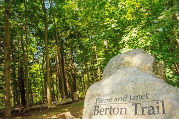
Pierre and Janet Berton Trail
Of the three main trails running through the park, the Pierre and Janet Berton is arguably the most publicized.
Getting there requires driving about 1.5 kilometres into the park from the main entrance off Islington Avenue, but there are ample signs to help you find your way.
There’s a large stone marker at the trailhead bearing the honorees’ names.  
The 1km loop trail existed for decades, but underwent improvements several years ago and was officially dedicated in May 2011 to recognize the prolific Canadian author and journalist and his family for  supporting the Friends of Boyd Park, a local group that successfully stopped the proposed extension of Pine Valley Drive through the conservation area.
The hard-packed dirt trail runs through a forested area of the park, which has been deemed environmentally sensitive, according to Grant Moravek, assistant supervisor at Boyd.
“There are things that grow here that don’t grow anywhere else – some special lilies, a natural spring that never freezes (and)… Jefferson salamanders, which is an endangered species,” said Moravek, a seasoned outdoorsman who has worked in the park for more than a decade, during a recent morning hike.
You’ll also find a wide variety of hardwood trees including cherry, some very old elms, birch, walnut and a few of the endangered butternut tree, “but they’re hard to find”, he said.
A mostly flat, hard-packed trail with a single boardwalk through a wet area, it’s ideal for beginners, Moravek said.
There used to be a stone bridge along the seepage area, but it was washed away by the frequent floods that occur here, he said.
The bridge was built by Dr. Edmund Boyd, an ardent conservationist who owned the property until 1954, when he sold it to the local conservation authority.
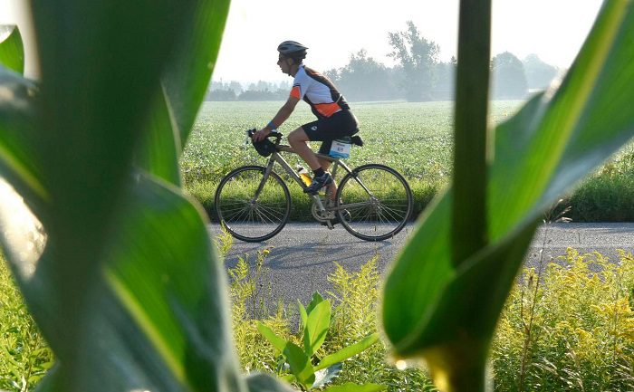
At the point where it loops back toward the park, the Berton trail joins up with the William Granger Greenway, a wide, crushed-gravel trail popular with hikers and cyclists that runs alongside the branches of the Humber River, all the way up to Bindertwine Park in Kleinburg.
Those looking for a longer hike can head north along the Granger trail. Others can head south, back into Boyd Park.
William Granger Greenway
The William Granger Greenway, which is part of the Humber River Trail, is named after a former TRCA chairman.
It meanders alongside, and occasionally crosses, the East Humber River with a connection to the grounds of the McMichael Canadian Art Collection.
Though largely flat, there are a few steep inclines along the route.
The section that passes through Boyd Park is mostly through open meadows.
At points, it affords some up close viewing of the East Humber River, which is a feeder stream for the main Humber.
“We get a good run of salmon in the fall and rainbow trout in the spring,” Moravek said. “Depending on the water level, sometimes you can see them running up and down through the culverts, under the bridges. There’s some natural speckled trout in here, too.”
The river is also home to the redside dace, an endangered species of minnow with a characteristic red stripe along the front half of the body.
They can be seen leaping out of the water to catch insects.
Also noteworthy about this route is that it lies along the historic Toronto Carrying Place Trail, an aboriginal trade route linking Lake Ontario to Lake Simcoe and the northern Great Lakes.
As such, artifacts have been found along the trail from time to time, Moravek said.  
Within Boyd Park, the Granger passes by an old quarry that was left to re-generate naturally.
Homes from the Islington Woods subdivision that abuts the park sit at the top of the ridge. Down below, out of sight from the trail, are a couple of wetlands that serve as home to an array of animal and plant species.
Red Trail
Those seeking a slightly more challenging hike – though still not terribly difficult — should consider the Red Trail, which runs along the top of the river valley through the densely forested part of Boyd park.
“It’s a good cross-country trail,” Moravek said.
There are three entry points to the trail, none of which are very well marked at the moment due to the devastating ice storm in December 2013.
One can be found at the rear of the Poplar Hill picnic site, located just inside the main gate off Islington Avenue.
For those wishing to drive further into the park, there are access points at the Valleyview picnic site, which provides for a shorter hike, and at the Cliffside 1 site, though, the latter trailhead is fairly steep.
Much like the Berton Trail, the Red Trail is packed dirt with lots of tree roots.
The terrain is undulating and the trail is quite narrow in some sections.
From the Poplar Hill trailhead, it runs alongside Islington Avenue for a fair distance, so depending on the time of day, the din of traffic can overwhelm the sounds of nature.
It then cuts a swath behind the Islington Woods subdivision before plunging into the forest at the park’s north end.
As you travel east along the trail, there are a couple of side trails with wonderful vistas of the East Humber.
It also affords you a view of the wetlands that have formed in the former quarry; the same ones you pass by, but can’t see, on the Granger trail.
All-in-all the Boyd Park trails are perfect for novice hikers looking to work up to more challenging treks or for those seeking respite from the sights, sounds and stresses of the urban jungle, says Moravek,
“You’re right in nature and if you’re into it enough to pay attention – to watch and listen – it’s a great place to be.”

Thursday, August 13, 2015

Ontario Trails News - Greenbelt Route nearly 500KM Cycling Trail

Find your Favorite!


New Greenbelt Route boasts nearly 500km of cycling trail in Ontario

Cyclists from cities across North America will gather in rural Ontario on Sunday Aug. 16 to celebrate a significant milestone in the province’s cycling infrastructure.
THE CANADIAN PRESS/Jonathan Hayward
 A A 
TORONTO – Cyclists from cities across North America will gather in rural Ontario this Sunday to celebrate a significant milestone in the province’s cycling infrastructure.
This year’s Great Waterfront Trail Adventure (GWTA) will coincide with the official launch of the new Greenbelt Route – a cycling trail that stretches nearly 500 kilometers from Niagara to Northumberland, Ont.
The 475 km Greenbelt Route was developed by the Waterfront Regeneration Trust. The new route combined with the Waterfront Trailform a 1,000 km signed and mapped cycling loop along the waterfront and through Ontario’s protectedGreenbelt.
The decade-old Greenbelt is 1.8 million acres of protected farmland, forests and wetlands. It’s the world’s largest protected greenbelt, protecting environmentally sensitive areas in Ontario from development and urban sprawl.
On Sunday, cyclists from 50 North American cities will be among the first to ride the new route.
The GWTA will start in Roseneath, Northumberland County – approximately 140 km north-east of Toronto – and end six days later in Queenston, Niagara.
Registration for GWTA 2015 is now closed, but cyclists wanting to tackle part (or all) of the route on their own can print off route maps from the Friends of the Greenbelt Foundation. The maps are meant to complement the 900 road signs posted along the Greenbelt Route.
The route itself is said to be a boon for Ontario’s cycling tourism industry.
“For the last seven years, the GWTA has helped build the Waterfront Trail’s reputation as a premier cycle tourism destination,” said Marlaine Koehler, Executive Director of the Waterfront Regeneration Trust. “It is fitting that this year, we host a special ride that showcases this new stunning addition to Ontario’s network of long distance cycling trails.”
Koehler added that the Greenbelt Route will help grow cycling tourism in the province, an industry that generates millions of dollars every year.
© Shaw Media, 2015